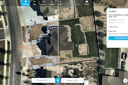
Nearmap captures, manages, and delivers high-res aerial imagery of the urban U.S. multiple times per year, and streams HD quality photo maps instantly to your desktop or mobile device utilizing MapBrowser, a cloud-based plateform for searching and navigating Nearmap’s library of current and historical aerial photos. Nearmap captures its imagery at 2.8" GSD, much clearer than the best satellite images.MapBrowser includes tools for measuring, designing and analyzing the various locations. Using measurement tools within MapBrowser, contractors can prepare bids from the office or anywhere through any device with Internet access based on location and season. This is a promotional video of Nearmap's 3D. For more information visit the Green Industry Pros Software and Technology Edition or Green Industry Pros product listing.
Nearmap 3D
Utilize MapBrowser, for searching and navigating Nearmap’s library of current and historical aerial photos
Aug 14, 2019
Latest in Videos
![U8kj71gt 720[1]](https://img.greenindustrypros.com/mindful/acbm/workspaces/default/uploads/2025/10/u8kj71gt-7201.8OyDyc124u.jpg?auto=format%2Ccompress&fit=crop&h=100&q=70&w=100)
Operator-Focused Innovations
October 24, 2025

Introducing the New AZA 700 Series from Stihl
November 6, 2024
A Closer Look at Yanmar America's E-Tractor
November 4, 2024

Oregon Discusses New Products at Equip Expo
October 22, 2024


![U8kj71gt 720[1]](https://img.greenindustrypros.com/mindful/acbm/workspaces/default/uploads/2025/10/u8kj71gt-7201.8OyDyc124u.jpg?ar=16%3A9&auto=format%2Ccompress&dpr=2&fit=crop&h=135&q=70&w=240)


