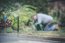
As the need for more sustainable landscapes continues to rise, landscape and other site design professionals are tasked with finding ways to reduce potable water use in their projects to meet sustainability objectives.
Designing hydrozones is a method you can use to plan for efficient temporary or permanent irrigation systems, ultimately reducing the amount of wasted water on a site.
We will explore the fundamentals of hydrozone planning and discuss how these principles can be applied in practical settings.
What is a hydrozone?
A hydrozone is a planned space that contains plants with similar watering needs. Grouping plants with similar needs allows you to maximize the efficiency of irrigation systems, helping ensure that you’re not over or under watering plants.
Many irrigation systems water the site inconsistently, thus wasting water. The water budgeting and hydrozones approach is better representative of the needs of the site and allows you to better select plants to match watering needs.
How to start designing hydrozones
The first step to designing hydrozones is to divide the site into five irrigation categories.
- Routine irrigation zone
- Reduced irrigation zone
- Limited irrigation zone
- Nonirrigated zone
- Special landscape area
Routine irrigation zones are parts of the site that require the most water the most frequently. It’s also referred to as the “principal irrigation zone.” These areas can include plantings like grass, turfgrass, vegetables and fruits.
Reduced irrigation zones require less water than routine irrigation zones but still require frequent watering. Often, perennial beds and shrubs will be in a reduced irrigation zone.
Limited irrigation zones contains plants with low water requirements. Typically plants in this zone would only need watering during dry spells. Temporary irrigation systems—ones that are installed to establish plantings and then removed—can fall into this category as well.
Nonirrigated zones get all their water from rainfall and/or surface drainage and require no additional watering.
Special landscape areas, abbreviated to “SLA” by Model Water Efficient Landscape Ordinance (MWELO), will consist of edible plantings. Though these areas typically have higher water use, they serve the sustainable purpose of feeding the client or community.
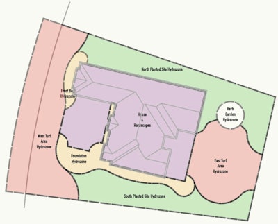
Create a bubble diagram
You can denote these zones by drawing with the polyline-based Hydrozone tool to represent them.
It can take some practice to get comfortable with placing the hydrozone bubbles in ideal positions. Though a lot of it depends on the project at hand and goals for the site, here are some general guidelines.
- Routine irrigation zones are either the most visible areas, most used areas, or both. They’re most visually captivating and are great for placing in prominent areas.
- Reduced irrigation zones are less used but are in prominent, visible areas of the site.
- Limited irrigation zones generally get little use.
- Nonirrigated zones tend to have the least human use.
Maximize native plant use
Native plants naturally exist in the given climate. They require less water than non-native plants and can often survive only on rainfall. Native plants would be in limited irrigation zones or nonirrigated zones.
Though these zones sound like they wouldn’t be as lush as a routine irrigation zone, if you decide to make them full of native plants, these zones can be just as vibrant on a fraction of the water use. Native plants can also be more disease and pest resistant.
If you’re unsure of what plants are native to your area, you can check with your regional native plant organization or university horticultural department.
Design software helps crunch numbers
Hydrozones created using software are intelligent objects that ease the reporting process. You can specify each plant and its needs along with the zone in which it will be planted and pull this information into a pre-made water budget worksheet, which can be used to calculate total water requirements for the zone. The worksheet can provide numbers such as water use per square foot, which in turn helps predict the site’s overall water budget.
If you’re working to meet LEED, SITES and/or MWELO objectives, this ability to report the water requirements of each hydrozone in your project quickly and easily is extraordinarily useful. You’re able to measure site success against the benchmarks provided by these sustainability organizations and initiatives, allowing you to make more informed decisions.
Originally published in July 2023.