Nearmap HD aerial imagery helps Elite Grounds, L.C, one of Utah’s largest full-service maintenance and landscaping companies, save 75% of time estimating potential projects while also improving accuracy. The Elite team uses measurement tools within Nearmap’s cloud-based platform, MapBrowser, to prepare bids from the office or anywhere — saving significant amounts of time, resources and money.
By incorporating Nearmap HD aerial imagery into its operations, Elite Grounds has access to clear, current imagery — a tool it can trust with its biggest projects. “Nearmap saves our staff between six and 12 hours minimum per job,” saidCameron Ashby, Systems Manager at Elite Grounds. “Eliminating time onsite and preventing change orders has reduced job estimate time by about 75%. The time savings have also allowed us to bid on more projects than ever.”
High-resolution aerial imagery has proven invaluable in larger projects. “This year we serviced and maintained all small Pocket Parks in a large developing community association, which is a big undertaking,” said Ashby. “With Nearmap, we saved about two weeks of company time in accurately measuring all of the parks.”
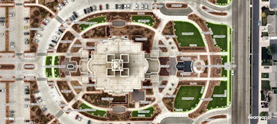
Nearmap captures its imagery at 2.8-inch GSD — much clearer than the best satellite images. Nearmap updates imagery multiple times per year keeping up with Utah’s rapid growth and development. With Nearmap imagery, the Elite Grounds team has access to up to four years of historical imagery. They can select imagery taken in the spring and fall, so foliage doesn’t get in the way of measurements.

“Increased accuracy of bids is the most critical factor to our customers and us,” said Ashby. “There is no better marketing than a happy customer and a beautiful end product.”
Ashby recounts a time when the team tested Nearmap’s abilities against traditional onsite measuring. Both sets of measurements were within just feet of each other. The deployed team took four times as long to gather measurements.
Elite uses Nearmap imagery even in the winter, when the company installs holiday lights on commercial and residential properties. The 3D line tool within MapBrowser helps the Elite team measure rooflines perfectly, so they can order the appropriate quantity of strands of lights during the holidays, eliminating excess inventory and guesswork.
Elite Grounds offers a broad range of services, including landscape construction and maintenance, sprinkler services, chemical services, snow and ice control, dormant pruning and holiday lights to municipalities, commercial and high-end residential properties in Utah and Salt Lake Counties. After several years of using low-resolution satellite imagery, the team turned to Nearmap to provide high-quality, aerial imagery that is frequently updated to provide the best service possible to clients.
Before Nearmap, Elite Grounds used satellite imagery from large mapping services, which was often old, blurry and lacked zooming capabilities. Satellite imagery is typically outdated and lacks resolution detail, making it extremely difficult for the team to produce accurate bids without also going to the client’s service sites.


![Doosan Bobcat Wacker Neuson Stack 2ec Js Pb V6e[1]](https://img.greenindustrypros.com/mindful/acbm/workspaces/default/uploads/2025/12/doosan-bobcat-wacker-neuson-stack2ecjspbv6e1.CPyyz8ubHn.png?ar=16%3A9&auto=format%2Ccompress&bg=fff&dpr=2&fill-color=fff&fit=fill&h=135&q=70&w=240)


