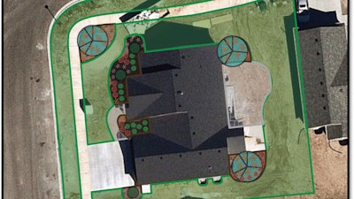
LandOne, a design and takeoff software for the landscape industry, has partnered with Nearmap to give its users access to the most up-to-date, high resolution aerial images available today.
When it comes to designing enhancements or doing takeoffs for job sites, having reliable imagery is paramount. While LandOne has the ability to work with drone photos, this integration allows its users to simply search an address in LandOne Takeoff and instantly capture a recent aerial view of a property that is often of comparable quality to a drone image.
“This integration is just another step LandOne has taken to revolutionize takeoff and enhancement sales for landscape professionals,” says Robert Maffei of The Maffei Companies. “Having been account managers, estimators, and business owners themselves, the team at LandOne is on a mission to provide the simple tool we need to sell more work and still make it home to our families on time.”
Nearmap aerial imagery delivers current, future, and historical images across 700 urban and regional areas, including the cities and suburbs that house over 80% of the U.S. population, surveying more than 308,000 unique square miles each year.
“Our users are loving this new feature,” says Joshua Martin, LandOne founder. “This week I worked with a new user to design a new planting for a pool patio that had just been installed this spring. With one search we pulled a hi-res image that was less than a month old and already had the new patio in it. We immediately began designing the new planting right on the image for them to sell.”
Create a free trial account and try LandOne’s new features at landonetakeoff.com.


![Screenshot 2025 04 02 15315367ed9ef4a98a61 f J Hvy6d3 Wq[1]](https://img.greenindustrypros.com/mindful/acbm/workspaces/default/uploads/2026/06/screenshot-2025-04-02-15315367ed9ef4a98a61fjhvy6d3wq1.R6OQhqU3ti.png?ar=16%3A9&auto=format%2Ccompress&dpr=2&fit=crop&h=135&q=70&w=240)


