Nearmap recently announced the general availability of new innovation Nearmap Artificial Intelligence (AI) in Mapbrowser, a series of datasets constructed from machine learning models deployed across Nearmap high-definition aerial images.
The launch marks Nearmap as the first among aerial imagery providers to offer both AI analysis and high-definition, frequently updated aerial images on a commercial scale. Nearmap AI datasets will allow users to automatically identify ground features, from tree overhang to residential footprints, track changes and verify insights against current aerial imagery at massive scale.
Nearmap AI will make it easier for organizations, regardless of size, to access and use AI-driven location intelligence to plan, manage and run their operations. For example, local governments will be able to use Nearmap AI to remotely appraise property developments and detect changes in public construction projects, while insurers can integrate the AI datasets as part of their underwriting and claims management processes.
“Our customers are the key drivers of our innovation, and they have been telling us about their increasing need to quickly gather location insights that can enhance their productivity and give them a competitive edge,” said Dr Rob Newman, Chief Executive Officer and Managing Director, Nearmap.“Nearmap AI is a product innovation breakthrough which has been in the making for some time now,” said Dr Rob Newman, Chief Executive Officer and Managing Director, Nearmap. “What’s unique about it is that it combines the best of both worlds -- data analytics and high-definition, frequently-updated aerial imagery. And when you add Nearmap tools for measurement, search and location identification, businesses get a solution that will exponentially help scale up their insight gathering efforts, with richer and more accurate data.”
Innovative Use Cases
Nearmap AI datasets are integrated with consistent, verifiable aerial imagery from Nearmap’s extensive library. The product capitalizes on highly-accurate machine learning models, tailor-made by Nearmap experts and deployed at massive scale across its high-definition aerial images.
Professionals across insurance, utilities and local government will be able to explore a variety of use cases, as reflected in the strong demand among early industry adopters during the beta period. These include:
- Automated property analytics, to facilitate risk underwriting and claims management
- Digital underwriting and claims processing
- Supplementary datasets to enrich risk modelling
- Property appraisals, including detecting changes in developments
- Assessments of development applications and permits
- Change detection for property valuations
- Public safety and planning
“We believe Nearmap AI will profoundly change the way we plan, build and maintain our cities and infrastructure today,” said Newman. “With this combination of data analytics and high-definition aerial imagery, local governments, for instance, will benefit from a birds-eye view and automatic analysis of their cities’ evolution, to inform their planning and construction efforts.”
Easy Access to AI Insights
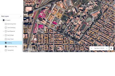
To access Nearmap AI, subscribers can purchase online or offline export credits, valid for an annual contract period, which will allow them to export AI-derived location intelligence content. Customers will be able to access AI Layers, which overlay Nearmap’s high-definition, regularly-updated aerial images in MapBrowser. They can also download relevant datasets for use within their own native systems through the AI Parcel Export function.
A freshly-processed set of AI dataset packages, available at launch, will allow automatic analysis and identification of ground features and changes over time. Current attributes include tree overhang, construction sites, residential footprints, roof materials and shapes, solar panels, pools, and trampolines. The list of Nearmap AI attributes is set to expand as Nearmap continues to deepen its product innovation efforts.
Technology Leadership
The commercial release of Nearmap AI marks the culmination of more than three years’ worth of research and development by a dedicated team of close to 20 Nearmap data scientists and machine learning engineers, and comes after an earlier beta program with a select pool of customers. To date, Nearmap has analyzed more than one million square kilometres of imagery across Australia and the U.S., constituting more than 90 million properties.
The new Nearmap AI product release represents another significant milestone for the company as it continues to invest heavily in its core technology and customer proposition, developing differentiated and high-value content types to its growing customer base. This follows the successful commercial rollout of Nearmap 3D and roof geometry in 2019, which further anchored Nearmap as a leader in the expanding location intelligence market.